16 days from Oregon to Hyder,
Alaska, the Yukon & the Alaska Highway
August 2015
3700 miles / 5954 kilometres
part 2
Here is part 1
DAY 6 (Thursday)
I missed the grizzly bear. Apparently, he or she walked behind me, foraging
for berries, while I was looking out on the lake after I'd just finished
peeing and was walking back to the tent from the outhouse at about 5:30 a.m.
Another camper that I passed on the way back saw the bear - they both saw
each other and quickly turned and walked the other way from each other. I
heard about it later that morning.
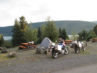
 We
loved Lake Meziadin Provincial Park. It's beautiful! The camp hosts
were friendly and helpful and engaged - not just hidden in their camper the
whole time. And the other campers were oh-so-quiet in the night - thank you,
whomever you are. We camped on a level above the lake-side level. There were
a few sites right by the lake, but we preferred to be away from the crowd.
We
loved Lake Meziadin Provincial Park. It's beautiful! The camp hosts
were friendly and helpful and engaged - not just hidden in their camper the
whole time. And the other campers were oh-so-quiet in the night - thank you,
whomever you are. We camped on a level above the lake-side level. There were
a few sites right by the lake, but we preferred to be away from the crowd.
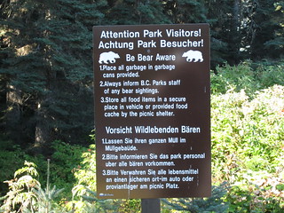
In addition to being beautiful, there are two signs in the park with
information in both English and... German. We're in Canada.
Why German? Why not French? Because far, far more German-speakers come to
the park than French speakers. Not sure if there have been any problems with
German speakers and bears... it just contributed to my theory that Germans
have traveling in their genes. And, yes, just like always, we met German
tourists everywhere. I don't even
mention it in my blogs every time - just assume, anywhere we are, we met
Germans. I've certainly met far more Germans traveling in the USA and Canada
than I've met Kentuckians... which depresses me... but I digress.
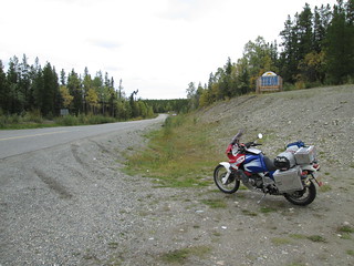
 We
were about 60 miles from Stewart, and since we had already gotten gas, we
could head straight there! It threatened rain all morning - but it never
rained. It was a beautiful day, just as the weather forecast as said. It was
a beautiful ride! It was one of those rides when I wished one of us had a
GoPro camera on our helmets, to capture the gorgeous scenery. We kept seeing
"end of avalanche zone" signs, but never saw the "entering avalanche zones"
signs - I finally noticed signs that were covered and turned away from the
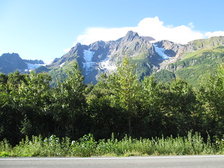
road, and figured it was those. On the way to Stewart, we stopped at Bear
Glacier. It made me think of Norway.
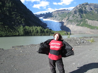
I had to show some university pride - that photo to the right is for you,
Western Kentucky University alumni. I was nervous that the road would start
to get difficult - sharper turns, greater inclines and declines - but it
never happened. The road is terrific.
We
were about 60 miles from Stewart, and since we had already gotten gas, we
could head straight there! It threatened rain all morning - but it never
rained. It was a beautiful day, just as the weather forecast as said. It was
a beautiful ride! It was one of those rides when I wished one of us had a
GoPro camera on our helmets, to capture the gorgeous scenery. We kept seeing
"end of avalanche zone" signs, but never saw the "entering avalanche zones"
signs - I finally noticed signs that were covered and turned away from the
road, and figured it was those. On the way to Stewart, we stopped at Bear
Glacier. It made me think of Norway.
I had to show some university pride - that photo to the right is for you,
Western Kentucky University alumni. I was nervous that the road would start
to get difficult - sharper turns, greater inclines and declines - but it
never happened. The road is terrific.
We entered Stewart and decided to stay at the King Edward hotel. There are
camping options in both Stewart and Hyder - I would have preferred Stewart,
had we gone that route, because there were restaurants and what not around -
but we figured we might stay two nights, in case we didn't see any bears
that day, and knew it was going to rain at least one of those nights. We got
a special rate at the hotel because we took the room next to the kitchen,
which was supposedly noisy. There were fans, and they did make noise, but
that was just white noise. There was some kind of banging for a while in the
morning, which was annoying, but it didn't last. The hotel didn't require us
to book a second night right then and there, which was great, because
staying another night depended on whether or not we saw bears that day. And
the staff are SUPER NICE. We unloaded the bikes and headed straight for
Hyder, Alaska with empty panniers, except for cookware and rain gear.
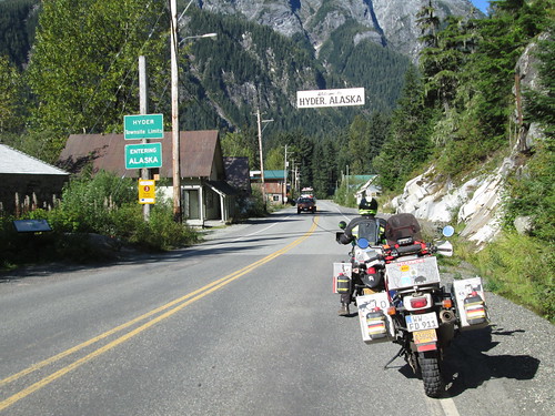 There's
no USA border check into Hyder. The road is paved all through town and all
the way to Fish Creek Wildlife Observation Site, otherwise known as WHERE TO
SEE THE BEARS. The site is run by the US National Forest Service and is a
day-use recreation area. Bears can be observed and photographed at the site
as they fish for chum
and pink salmon in the clear shallow waters of Fish Creek and Marx
Creek. Bears use the site from mid-July through early September, following
the arrival of salmon that return to the fresh waters of the creeks to
spawn... and
die.
There's
no USA border check into Hyder. The road is paved all through town and all
the way to Fish Creek Wildlife Observation Site, otherwise known as WHERE TO
SEE THE BEARS. The site is run by the US National Forest Service and is a
day-use recreation area. Bears can be observed and photographed at the site
as they fish for chum
and pink salmon in the clear shallow waters of Fish Creek and Marx
Creek. Bears use the site from mid-July through early September, following
the arrival of salmon that return to the fresh waters of the creeks to
spawn... and
die.
We stopped at the observation site and paid for a day pass, and talked to
the helpful site employee, who answers the same questions over and over
again, all day, every day, all summer. He said that seeing bears was a
matter of luck as much as anything, and since there hadn't been any bears in
the evening for about three nights, this evening might be a great chance.
Otherwise, he suggested sunrise the next day. Since we had many hours until
evening, we decided to head for Salmon Glacier. We left my motorcycle at the
observation site parking lot, and I rode on the back of Stefan's bike up to
Salmon Glacier.
The road becomes unpaved just past the observation site, and there's no
warning about the road being especially difficult - no prohibitions on RVs
of a certain size and all that, probably because huge semis do go on part of
the road, which we think is maintained by a mining company. I didn't want to
ride the road myself, on my own motorcycle, because I was afraid it would
get very narrow and very steep and had hairpins. It never did. It
does get high, but the drop offs don't look horrible when you are
actually on the road (just
when you look back at it). Even the potholes weren't that bad. It's
still not a road for everyone, and while I believe I could have ridden
it, I couldn't have in the rain. But that said, it was really nice to not
worry about it and just be on the back of Stefan's bike for the ride up. Two
or three adventure motorcyclists were on their way down as we road up.
I don't recommend the road up to Salmon Glacier for anyone towing a trailer
- leave your camper trailer back in Hyder or Stewart. And I absolutely don't
recommend the road for anything longer than 24 feet. This is both because of
the nature of the road and because of how small the parking lot is at the
glacier.
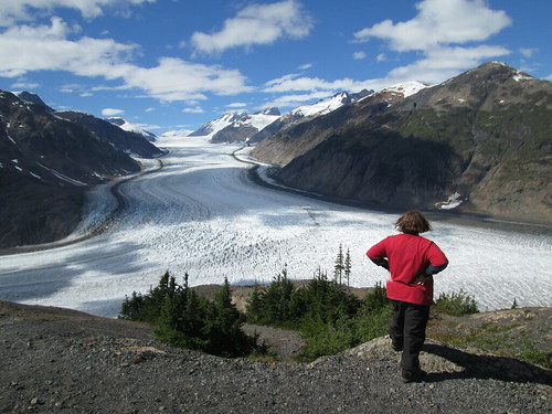 Salmon glacier is nothing short of spectacular. I've never seen anything
like it, in-person, in my life. Absolutely amazing. Photos just don't do it
justice (though
we tried!). We were blessed with the best weather the region had had
in two months, and weather predictions said there would be rain the next
day. We stayed for a couple of hours, just staring at the glacier and taking
photos. I knew I was experiencing what was probably the highlight of our
entire trip. I think this glacier may ruin us for all other glaciers.
Salmon glacier is nothing short of spectacular. I've never seen anything
like it, in-person, in my life. Absolutely amazing. Photos just don't do it
justice (though
we tried!). We were blessed with the best weather the region had had
in two months, and weather predictions said there would be rain the next
day. We stayed for a couple of hours, just staring at the glacier and taking
photos. I knew I was experiencing what was probably the highlight of our
entire trip. I think this glacier may ruin us for all other glaciers.
There is a well-maintained pit toilet at the viewing place for the glacier,
and a guy from New Brunswick selling postcards and DVDs of bears - he lives
in that parking lot all summer, in a beat-up tent and an even more beat-up
car. He'd had a good year - he was sold out of a lot of things. But I
worried about him... he looked tired and weather-worn and not well taken
care of. A little desperate. There were also three or four RVs driven by
Europeans taking months, even years off, to travel around the world. No,
Stefan was not the only German there. He never is. I was the only Kentuckian
there. I usually am.
After spending oh-so-long at the glacier, we went back down the road - which
was scarier than going up, and Stefan said I was trying to steer with my
hands on his hips. We got my bike and headed back into Stewart. There is a
fully-staffed Canadian border crossing into Stewart - and they asked us a
lot of questions, just like back at Sumas. In fact, the woman inside said,
"random", and the roving border guard announced Stefan would get a random
search. Luckily, she asked to see in only one pannier - lucky not because we
had anything inappropriate, but because it would have been a pain in the
butt to open each of them. But it confused me - there's no way to get into
Hyder except via Stewart, and there's no where to go from Hyder except back
into Stewart. Also, who takes care of law enforcement in Hyder? How do they
get mail? What if you're having a baby and you live in Hyder - and you want
your baby born in the USA? What if you are a Canadian and want to have a
baby in Hyder just to have a baby in the USA? So many questions...
We went back to the hotel, changed clothes, and walked around Stewart on the
gorgeous, warm, sunny day. It felt magical. The town looks like the one in Northern
Exposure. We dropped by the visitor's center and loaded up on
brochures for our routes after Stewart. We also checked out the outside of
the Ripley Creek
Inn. They've renovated all these old buildings into hotel rooms, and
we didn't have time to explore it more. But online, it looks GORGEOUS. It's
exactly the kind of place I DREAM of staying. Next time... next time...
seriously, I'd like to have a second honeymoon there. Outside of the main
offices of the inn, we found this
delightful antique snow car - which Stefan thinks may still be in
working order, giving how the inside looked.
We had lunch at our hotel's restaurant, washed our exOfficio underwear and
hung it to dry all around the bathroom, and then we napped. Oh how we needed
a nap. It was a luxury we rarely enjoy on these trips. We'd be returning to
the bear platform that evening, and had decided we were going to be there
for two, maybe three hours, in our quest-to-see-bears. We really didn't want
to have to get up at 4 a.m. the next day and have to decide to either check
out of the hotel or book another night then. I woke up before Stefan, and
got to pour over all the brochures we'd picked up earlier, which helped me
understand just how vast British Columbia is.
At 6:30 p.m., we rode back to Hyder and to the Fish Creek Wildlife
Observation Site. The parking lot was almost full, unlike when we'd been
earlier. We drove to the end of the parking lot and got onto the very end of
the platform, which goes along one of the creeks, and walked toward the main
visitor's site. We were entirely alone on the walkway - everyone else was at
the main site. We got to the place to walk to the left and go to the main
site - and there was a black bear, poking his head out of the shrubbery in
the creek ahead of us. I gasped. Stefan snapped off a few photos. Only us
two and the site volunteer saw the bear - when other visitors realized we
were watching a bear and started heading our way, the bear went back into
the shrubbery.
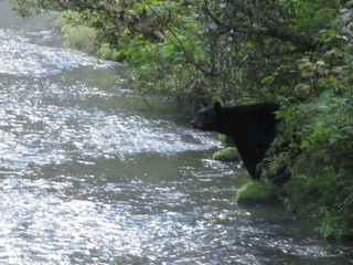 A
BEAR!! A BEAR!!! WAHOO!!!
A
BEAR!! A BEAR!!! WAHOO!!!
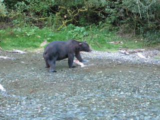
We were ecstatic. We walked around the tiny office, to the main platform,
where several dozen people were waiting for the bears. I was leaning against
the railing, writing in my journal and looking out on a little pond, hoping
the black bear we'd seen earlier was headed this way and would appear, but
just so happy to have seen a bear in the wild already, and saying to myself,
if that's the only bear you see, that's enough. That's awesome. After about
30 minutes, what appeared out of shrubs next to the pond was not the black
bear we'd seen earlier. It was a grizzly bear! And here's the shock: the
crowd got even MORE quiet. Absolutely silent! It was the antithesis of our
experience on Yellowstone: people were respectful of the animals and in awe
of the moment and ready to do what it took to make the moment last. I
started to get teary-eyed, both at the awesomeness of this gorgeous
creature... killing other creatures (the dying salmon)... and at how the
crowd was acting. It was a rare moment of loving humanity. Why can't they be
like that all the time? Pity those that left after the grizzly finally left,
because another grizzly bear showed up a bit later to enjoy the buffet.
Here's a
photo that shows just how close you get to be to the bears.
 We
stayed on the platform until nearly nightfall. And as we were leaving, a
black bear came strolling across the highway - a site volunteer
stopped traffic and kept some guys in the parking lot with cameras from
being idiots.
We
stayed on the platform until nearly nightfall. And as we were leaving, a
black bear came strolling across the highway - a site volunteer
stopped traffic and kept some guys in the parking lot with cameras from
being idiots.
I would love to ply the volunteers with alcohol and hear their horror
stories about tourists behaving badly - because I know they don't always act
as well as they did with us. I asked one of the volunteers if, on a night
when there were no bears and there was a huge crowd of anxious people, he
was ever tempted to wear a bear suit and jump out of the bushes and start
dancing. He got a very wistful look in his eyes... I'm like a muse.
We went back through the Canadian border, and I know my eyes were glassy - I
was in the post-bear-viewing glow. I was high - high on bears! And of course
I had to tell the border guards all about it. And of course they shooed the
crazy lady and her husband along quickly. We went back to the hotel to park
our bikes, and I informed the front desk clerk of the evening's events, so
she could update their lobby card, which provides info on the last time
bears were seen. I wish I'd taken a photo of it - she put a smiley face on
it, because it had been so long that so many bears had been seen at the
site.
We walked down the street, me floating on air, and had pizzas. Stefan drank
beer, I drank wine. But nothing could get me more stoned that seeing those
bears. The bears, the glacier, the gorgeous scenery, the little town - it
was one of the greatest days we've ever had while traveling. I will cherish
it for the rest of my life. I will go there in my mind whenever I am sad.
DAY 7 (Friday)
No need to stay another night in Stewart - we'd done all we came to do. The
morning wasn't great at the hotel - it was very loud, some kind of pounding.
But we were leaving and didn't care. We packed up, had breakfast in the
hotel restaurant, listened to the German tourists at the table near us, paid
our bill, and headed out of now-beloved Stewart. Just before we got on our
motorcycles, Stefan, who doesn't say much, just said, off hand, "I'm so glad
you like this (kind of) shit." It's one of the nicest things he's ever said.
Yes, I do. Okay, sometimes, I'm bitching and whining my way as we go. I have
my limits. I sometimes have to say NO, because I'm past my limit. But
ultimately, I love this. I love camping, I love getting dirty, I love the
adventure, I love how quickly the day can change. The best places in the
world have only a pit toilet, and I'm just dandy with that. And I love my
husband for taking me to these places and pushing me to do more and see more
than I ever would on my own.
We headed back to Meziadin Junction, got gas, said goodbye to a French woman
in an RV that we'd met at the glacier view point, read the license plates of
all the other people getting gas, and then it was time to head up the
Stewart-Cassiar highway, all the way to the Yukon. Would we go to Skagway?
We were still debating. It would depend on the weather and how far we went
this day.
The first part of the ride was great, especially when, just after we left
the gas station, I looked over on the left side of the road, and there was a
black bear, standing up, looking at me. A BEAR!!! Right there, looking at
ME. I gasped yet again... I will never forget that moment!
An accommodation tip for the
Stewart-Cassiar Highway: there are very
few places where you can camp, officially, and even less places to get a
room. If memory serves, the only places that have rooms on the highway
are Meziadin Junction (I think it's just bunk houses), Bell II resort
(more about that in the next paragraph), Tatogga Lake Resort, and Dease
Lake, which has a few hotels, but the night we were there, ALL of them were
full. In between these places, there's nada - no hotels, no cities. You have
an eight hour limit at rest stops, which are surprisingly plentiful, and
while it says no camping, the reality is, people camp there, in RVs. If we
had had to, we could have done it in a tent. Who is going to send us off, to
where? There is NOTHING around! And most have very well-maintained pit
toilets.
It started to rain, but not too bad. And we have great weather gear -
nothing heated, but thermal, and rain gear that keeps us dry. I wasn't cold,
not really. Whenever I put on my rain suit, I look at Stefan and say, "Does
this rain suit make me look fat?" At least I try to. Because I burst out
laughing every time before I finish. I can never do it with a straight face.
There is a prohibition on photos of me in my rain suit.
After about 60 miles (94 kilometres), we stopped for coffee at Bell II, a
luxury resort catering to heli skiing: they take you and your skis, in a
helicopter, to the mountain top of your choice and down you go. People also
stay there just to hike, or to fish, and to enjoy the gorgeous scenery. It's
ultra chic, but very friendly, and
the room prices actually aren't outrageous: they are the same as what you
would pay for a name brand hotel outside of a major national park. We found
out later, by looking at the web site, that they have camp sites available -
just $23, Canadian, for a site. They really should put a sign out on the
road so people know that. The snack shop's butter nut squash called to me,
but it wasn't quite lunchtime yet, so we settled on coffee. The snack shop
staffer, who is a heli boarder, gave me a quick tour of the ground floor of
the resort. Oh, la la! She said that they have a very small staff in the
summer - they would happily hire more folks, but they've had too many people
show up to work and freak out after just a week because of lack of Internet
and feeling so isolated. I said that, to work at a place like that, you
really had to like yourself. And most people don't really like
themselves.
We pushed on, now in full rain gear because we were in a downpour. After
even more rain, we were at Tatogga Lake Resort. Very good food, but not so
great service - we were there much longer than we should have been, waiting
for someone to take our order, then waiting for our food, then waiting to
pay. That said, they were SUPER helpful about trying to help us find a list
of hotels and camp sites in Dease Lake - which they never could quite find.
Also, they've got a sign out front about how Loretta Lynn once ate there,
and I was all over it. It was after 4, and they kept saying we REALLY should
stay there... and we should have, we know now... but we pushed on, and the
rain got even worse. And then the paved road ended and we came upon some
gnarly gravel on a very wide but still hairpin turn that was on a steep
descent. I was not happy. NOT HAPPY. Added challenge: the water on my visor
was no longer beading; all I saw was a big blur of colors. I couldn't see
any of the texture of the road at all. I was riding with my visor open a lot
of the times, just for visibility - getting smacked in the face by the rain
as a result, and terrified of a rock or large bug coming my way at any
moment.
By the time we got to the town of Dease Lake, it was well after sunset, and
every hotel was full. The idea of camping in the absolute downpour was
disheartening. We were cold, wet and tired - and it was getting dark fast. A
guy in a white van with a Texas license plate heard me say that the young
girl working in the grocery store said there was no more hotels anywhere, so
he said, "Excuse me, I don't know if this will help, but I just came from
the direction you're headed, and just 10 minutes up the road, I know I saw a
sign at a camp site that said 'Cabin Available.'" I wish I had thanked him
profusely, because we chanced it, and just five minutes north, there was the
sign, and down a steep dirt road, right in front of the Water's Edge
Campground, there
was the cabin. And it was available. I almost started to cry when the
manager said it was available. No electricity, no in-door plumbing. But it
was dry. That's all I wanted.
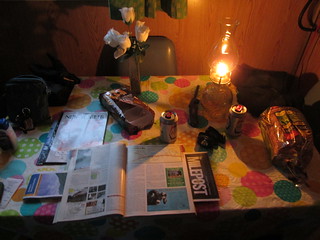
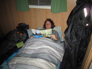 We
unloaded our bikes, took off our sopping wet gear, drank beer, ate cookies
and PLAYED ON THE INTERNET. Yes, we had some of the best Internet access
we'd had in a while - in a fishing cabin with no electricity. I read more of
one of my NewYorker Magazines. I
was warm, dry, and oh-so-happy. I loved the light by oil lamp - and when it
got completely dark, I read by head lamp. Because there was no heat, we
slept in our sleeping bags on the bed, and I threw on a comforter for extra
coziness. I don't think Stefan realizes just how much I loved this night. It
could have turned out so differently. It was a really ROTTEN three hours
before we landed here, and I was miserable the whole time. Now, I was so
grateful to luck and that guy in the white van, and I was warm and dry and
so happy. It was on this night we were introduced to Milepost,
a massive magazine published annually. "Legendary Alaska trip planner and
Alaska travel guide to the highways, roads, ferries, lodgings, recreation,
sightseeing attractions and services along the Alaska Highway to and within
Alaska, including Alberta, British Columbia, Northwest Territories and the
Yukon." It's outstanding - if we do a trip all the way to and into the
Alaska mainland, we are making room for this on the motorcycles, no
question. There's just no guarantee you are going to have Internet or phone
access on a trip like this.
We
unloaded our bikes, took off our sopping wet gear, drank beer, ate cookies
and PLAYED ON THE INTERNET. Yes, we had some of the best Internet access
we'd had in a while - in a fishing cabin with no electricity. I read more of
one of my NewYorker Magazines. I
was warm, dry, and oh-so-happy. I loved the light by oil lamp - and when it
got completely dark, I read by head lamp. Because there was no heat, we
slept in our sleeping bags on the bed, and I threw on a comforter for extra
coziness. I don't think Stefan realizes just how much I loved this night. It
could have turned out so differently. It was a really ROTTEN three hours
before we landed here, and I was miserable the whole time. Now, I was so
grateful to luck and that guy in the white van, and I was warm and dry and
so happy. It was on this night we were introduced to Milepost,
a massive magazine published annually. "Legendary Alaska trip planner and
Alaska travel guide to the highways, roads, ferries, lodgings, recreation,
sightseeing attractions and services along the Alaska Highway to and within
Alaska, including Alberta, British Columbia, Northwest Territories and the
Yukon." It's outstanding - if we do a trip all the way to and into the
Alaska mainland, we are making room for this on the motorcycles, no
question. There's just no guarantee you are going to have Internet or phone
access on a trip like this.
Let me say a word about Internet access: it's vastly better than I ever
dreamed it would be on a trip like this, but still, you can't count on
having it. I had it in this cabin, believe it or not - I was able to tweet
and read tweets, but not to read and send Facebook posts. I didn't even try
email. That's how it was more often than not when there was Internet access
after Smithers, and until we were in Dawson Creek at the end of the Alaska
Highway (or the beginning, for most people). There is no real Internet
access in Stewart or Hyder - don't even hope for it, even if you stay at a
hotel.
DAY 8 (Saturday)
Once again, I had a great night's sleep. 10 hours! I couldn't believe how
well I was sleeping on this trip, from night one. I am really, really into
sleep on vacations - without it, it's not vacation, it's me in a continual
bad mood in interesting places, not enjoying them. It's me with headaches.
But this was one of the only nights - maybe the only night - where I slept
this much.
We were able to use the gas grill out on the tiny front porch to heat up
water for coffee, my oatmeal and face washing. I cleaned my visor
thoroughly, and it was better. And then it was time to head back to the the
Stewart-Cassiar highway.
I knew now that this trip would not include Skagway and Haines. We still had
the days to do it, but the weather forecast was absolutely wretched: rain,
rain and more rain. We'd drive to those towns in the rain, spend time there
in the rain, and leave in the rain. It just didn't sound appealing. Instead,
we were driving to Yukon, and then head South on the legendary Alaska
Highway through British Columbia, no matter what the weather. And maybe we
would head straight home or divert over through Jasper. Time would tell.
 I
was having a lot of trouble quickly translating kilometre signs into
mileage. 1 mile is 1.6 km. 5 miles is 8 km. 50 miles is 80 km. 25 miles is
40 km. These are the things running through my head as I would see distance
signs, since doing math without paper and pen is impossible for me. It
didn't matter - I could never figure out how far we were from anything. I
frequently underestimated.
I
was having a lot of trouble quickly translating kilometre signs into
mileage. 1 mile is 1.6 km. 5 miles is 8 km. 50 miles is 80 km. 25 miles is
40 km. These are the things running through my head as I would see distance
signs, since doing math without paper and pen is impossible for me. It
didn't matter - I could never figure out how far we were from anything. I
frequently underestimated.
You can almost miss the sign for the border into Yukon on the highway. And
you can't easily get a photo with it - it's high up on a steep gravel hill.
That was disappointing. But even though Yukon didn't look any different than
a lot of places I had been, I was thrilled to be in Yukon, my fourth
Canadian state ever (I've also been to Alberta and Manitoba). I'd like to
see more of it, actually - I hope that's possible on another trip. I felt so
far away from home. From everything. Like I did in Scotland, especially the
Orkney Islands.
I find it funny that, with this trip and our tip in 2010, I've been all over
British Columbia - but never been to Vancouver. The only Canadian big city
I've been in is Winnipeg (NOT a fan...). I would really like to see
Vancouver, Toronto, Montreal and Calgary some day. But NOT via motorcycle.
 Less
than two miles after crossing into Yukon, we came to the turnoff onto Alaska
Highway 1. I was sad to leave the Stewart-Cassiar Highway. I had provided
quite a wonderful adventure, very good road conditions, and not much
traffic.
Less
than two miles after crossing into Yukon, we came to the turnoff onto Alaska
Highway 1. I was sad to leave the Stewart-Cassiar Highway. I had provided
quite a wonderful adventure, very good road conditions, and not much
traffic.
It wasn't raining nearly as badly as the day before, but it was still
raining, and the skies were still oh-so-gray. After about 10 miles, we were
in the town of Watson Lake. We stopped for gas on the left side of the road,
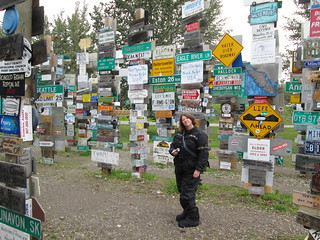
and then saw that the Sign Post Forest was right next door. I'd never heard
of it, but Stefan had - but he thought it was actually in Alaska, so he
didn't bring a sign. Next time!
The "forest" was started by a homesick GI from the USA in 1942. Visitors may
add their own signs to the more than 100,000 already present. We found
several signs from Germany and even a few from Kentucky, like this
one from Vicki and Charlie Helms from Owensboro in 2003.
The visitor's center is right next to the "forest", and geesh were they
helpful: they suggested a place for lunch, they had a one-sheet flyer that
noted every gas station, camp site and hotel between Watson Lake and Fort
Nelson on the Alaska Highway, and they called ahead to a hotel for us - and
we got the last room there! We also met other motorcycle travelers for the
first time on this trip - we saw lots on the road, but this was the first
time we got to talk to any. It was a guy from Arizona and a guy from the
Netherlands, who'd just met in that moment as well. The Dutch guy was on his
way to Alaska, and will eventually come back down, probably through Oregon,
so Stefan gave him a card. We'd seen no motorcyclists at all coming down the
Cassiar highway on our way up.
We would have stayed in Watson Lake if it had been clear, because the
Northern Lights were supposed to be spectacular that night. We've never seen
them, and Watson Lake promotes itself as a perfect place to see them. But
the clouds were oh-so-thick, the rain constant - it wasn't happening.
 Our
way down the Alaska Highway that day was... well, it was okay, and I
welcomed a boring ride, but I wondered if the whole ride would be this way.
It
wasn't all that scenic. It started raining again, but it was light and
manageable. We stopped at a rest area and, without intending to, had found
one of the suggested stops from our one-sheet: Whirlpool Canyon, a scenic
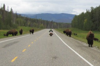
view of Mountain Portage Rapids. We continued on, and the wildlife all those
warning signs had promised showed up: suddenly, there were buffalo,
everywhere. We were oh so careful as we went through them.
Our
way down the Alaska Highway that day was... well, it was okay, and I
welcomed a boring ride, but I wondered if the whole ride would be this way.
It
wasn't all that scenic. It started raining again, but it was light and
manageable. We stopped at a rest area and, without intending to, had found
one of the suggested stops from our one-sheet: Whirlpool Canyon, a scenic
view of Mountain Portage Rapids. We continued on, and the wildlife all those
warning signs had promised showed up: suddenly, there were buffalo,
everywhere. We were oh so careful as we went through them.
We saw quite a few motorcyclists on their way up the highway, headed north -
less than a dozen but, still, that was more than I thought we would see.
We stopped at a hotel for the night at Liard River Hot Springs. The
Provincial Park across the street had a "full" sign, but our hotel also had
camping, and I don't think it was full - but we thought it might rain, and
had wanted a hotel room. Stefan
did some overdue maintenance on our motorcycles, tightening and then
lubricating the chains and checking the oil. I don't think motorcycle
travelers talk enough about doing this kind of maintenance. Our chains got
very loose after every 1000 miles, and it's dangerous not to adjust them
promptly and regularly. We could have gone over to the hot springs at the
park if we'd brought our swim suits - we hadn't - but honestly, we were just
DEAD tired. Absolutely exhausted. If you stay at this hotel, a warning:
BRING EARPLUGS. The rooms are not sound proof at all. We were in the only
ground floor room, and until everyone went to sleep, it was unbelievably
loud - you could hear everyone going up and down the stairs, and in the room
above us. In the morning, we woke up because someone had turned on the TV in
the lobby. Still, I was able to sleep.
At some point between Stewart and here, as I was looking at the literature
we'd picked up at the visitor's center, I found out we were doing an
official British Columbia tourist office driving route: "The Great
Northern." It said so in our Circle
Routes Scenic Driving Guide that I'd picked up. It's a fantastic
guide! Apparently, we also had done half of the "Heritage Discovery" route,
and would also be doing half of the "Hot Springs" route, half the
"Ranchlands & Rivers" route, and half of the "Lakes & Trails" route.
I think in 2016 or 2017, we could do both the "Costal" route and the "Coast
Cariboo", which together give us the other half of the "Heritage Discovery"
route. And by then, we will be experts on British Columbia... but still
won't have visited Vancouver. Seriously, motorcyclists in Oregon, Washington
state, Idaho and Montana should have this guide! It's free!
continued in part 3
Here
are all the photos from this trip.
Also see:
Tips for Women: Getting Started as a
Motorcycle Rider (just to ride, not necessarily to travel as well)
For Women Who Travel By Motorcycle
(or want to)
Advice for Women
Motorcycle Travelers: Packing
Advice for Women Motorcycle
Travelers: Transportation and Accommodations Choices
From Oregon to the "Lost Coast" of
Northern California (Horizons Unlimited 2010 California meeting) -
August 2010
Oh, Canada...Two-Week Canada/USA Tour by
Motorcycles (Oregon, Washington, British Columbia, Alberta,
Montana, Idaho) - September 2010
Oregon, Idaho, Yellowstone, &
More - June 2011
Crater
Lake, Oregon 2011 (photos only)
Weekend
camping trip in Eastern Oregon, May 2012 (weekend before Memorial
Day).
Gifford
Pinchot National Forest / Southern Washington State, July 2012,
two 1/2 days, 322 miles.
Northern
California, Nevada, Southwestern Oregon, September 2012
Utah & Nevada, June 2014
Return to the broads abroad home page
Disclaimer
Any activity incurs risk. The author assumes no responsibility for the use
of information contained within this document.
A Broad Abroad | contact me
The content of this page is by
by Jayne Cravens, 2015, all rights reserved