A friend in Kabul sent me short videos of men throwing snowballs at
each other in the beautiful, newly-fallen snow. And I love it... but
the lack of any women on the street whatsoever is heart-breaking.
#Afghanistan
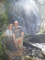
Backpacking start points near PDX
disclaimer
I created this page primarily for my friends visiting me. Some want
to backpack for 2 - 20 days at a time. I don't. That time for me is
over (because of my knees, which can't hold the weight of a backpack
anymore). But note that many of these suggested trips can be broken
up into day hikes, either where
you drive from PDX to the trailhead, hike for a while, then go back
home, or, where you camp in one camp site the night before and the
night after, and spend the day in between hiking (with just a day
pack rather than a full back pack).
Camping in Oregon is wonderful - but it is also so popular it can be
difficult to do in certain areas without reservations months in
advance. And as state forests and many national forests don't take
camping reservations - and that's most of the camp sites between PDX
and the coast - it can be even more difficult; for instance for any
holiday weekend, where the holiday is on Monday, you will not be
able to camp at any camp site that doesn't take reservations within
a half day's drive of Portland, unless you get to the camp site and
set up a tent by WEDNESDAY. I'm not kidding. For an in-season
weekend, such camp sites are often filled by noon on Friday.
Here are some back packing trips from our area. You are STRONGLY
encouraged to obtain a book that details the hike you choose and
gives you the necessary information on camp sites, safety, and
where to look online for trail closures. I have not done ANY of
these AT ALL - I put this together for a friend. Also, note that
many of these require you to get a permit - look on the web for
more information for the kind of permit you need and where to get
it.
One note: while camping light is important, packing what YOU
need, the way YOU want to, is also important. And don't worry
about having the latest gear. This is an excerpt from an
article from Backpacker Magazine, by a guy that still uses
an external frame backpack, and I completely agree:
A high percentage of people I pass on the trail pack like I
do—with some creature comforts—especially if they are taking
children into the woods. Maybe you can argue that they ought to
carry less, but, as a person accurately described as old-school,
I argue that hikers ought to carry exactly what they want, and,
if that means more gear, then external-frame packs are the best
option. They distribute weight better, are easier to pack, have
plenty of side pockets, myriad places to tie loose items, and
they have far better ventilation. Plus, there is the retro-cool
factor—like driving a Camaro you’ve wanted since high school...
I flat-out prefer external-frame packs. I hope that, once the
gram consciousness that now almost theocratically defines the
backcountry loosens up a bit, more people will realize that
external-frame packs are worth their weight in reading material
and vodka.
PCT = Pacific Crest Trail
Dry
Creek Falls, 4.4 miles one way (so 8.8 miles in and back).
Columbia River Gorge
The trailhead for this short hike begins at the day use park on the
south side of the Bridge of the Gods in Cascade Locks. A reviewer
said, "It's interesting to see how the PCT crosses under Interstate
84 and weaves through the only incorporated city located directly on
the 2,650 miles of the trail." Hike two miles on the PCT, then take
a short side path to Dry Creek Falls. Despite the name, it's another
gorgeous gorge waterfall. Back at the trailhead, take time to walk
across Bridge of the Gods. The roadway isn't very wide, so stay
along the railing and face traffic. Do this during daylight only.
"The view is amazing, much better than when driving across." Here is
a review of the trail going South from Bridge of the Gods. Combine
this with more of the PCT for a backpacking trip.
Timberline
Trail Loop , Mt. Hood National Forest, 40 miles
The Timberline Trail circumnavigates Mount Hood, and takes two to
three days depending on your abilities. This is a loop trail with
"alpine vistas, waterfalls, alpine meadows and west side Cascade
forest... Most hikers find the fast moving river fords to be the
most challenging part of the trail. Newton, Coe, Muddy Fork, Sandy
and White Rivers are typically the most challenging fords but are
typically not more than knee deep." It is considered VERY DIFFICULT
due to length and elevation changes. Most people seem to favor
beginning at the Timberline Lodge parking lot and hiking west, or
clock-wise. Experienced hikers do it in two-three days, thus
requiring two overnight stays along the trail. You will want to get
a great map and plan, in general where you will camp each night. One
reviewer said, "Don't tell anyone, but the 40 miles of the
Timberline Trail around Mount Hood pack nearly as much scenic punch
as the 460 miles of the PCT in Oregon. This is more a compliment to
the Timberline Trail than a snipe at the PCT. Case in point: The
Timberline Trail here leads directly toward McNeil Point and the
Sandy Glacier for views of Mount Hood exactly like you get in
Portland, only 45 miles closer."
Salmon
River Trail, Mt. Hood National Forest, 14.0 miles, one way
(can be made a much longer loop)
The Salmon River Trail runs through beautiful old-growth forests and
has camping spots throughout. There are supposedly several
established campsites along the way for backpackers. This is the Trail
Description and Map (PDF File). To make add more miles and
make a beautiful but difficult 15 mile loop, follow the Salmon River
Trail trail southeast 6.3 miles to Kinzel Lake Trail #665. Go left
(northeast) on Kinzel Lake Trail #665 and travel 2.2 miles to
Hunchback Trail #793. Go left (northwest) on Hunchback Trail #793
and travel 3.6 miles to Green Canyon Way Trail #793A. Go left
(southeast) on Green Canyon Way Trail #793A and travel 3.2 miles to
Salmon River Road (Forest Road 2618) and Green Canyon Campground.
Get a map that shows camp sites!
Timothy Lake, Mt. Hood National Forest, 13 miles
It's best to camp at the campsite here the night before and the
night after your hike - then you don't have to carry all of your
camping gear. Hiking is relatively flat around this reservoir. Begin
near the campground at Little Crater Lake and include about three
miles of the PCT on the east side of the circuit.
Paradise Park, Mt. Hood National Forest, 10 mile loop
You go west on the PCT and north of Timberline Lodge. One reviewer
called it "the most beautiful section of the national scenic trail
in Oregon." Make a 10-mile loop from the lodge by circling the
wildflower meadows of Paradise Park for above-timberline views of
Oregon's highest mountain. Above-timberline views of Mt. Hood.
Olallie Lake to Little Crater Lake in Mt. Hood National Forest
(or vice versa) - 34.9 miles (one way)
This is part of the Pacific Crest Trail. One blogger I found said
Olallie Lake is very peaceful, with lots of ducks and duck
enthusiasts. It has amazing views of Mt. Jefferson. I've read that
there is a water source every 10 or so miles. There is camping at
Timonthy Lake and at Little Crater Lake - these can be your start
points or your end points. Not sure what camping there is in
between. Get a map that shows camp sites! Here is a blog
about the hike from Olallie Lake to Timothy Lake, and here is
information by someone that went from Timothy
Lake South to the Whitewater Trailhead. (50.5 miles). They did
it like this:
Day 1 – Little Crater Lake Campground to Dry Camp: +500, -250, 7
miles.
Day 2 – Dry Camp to Seeping Spring Camp: +1,400, -1,000, 9 miles.
Day 3 – Seeping Spring Camp to Jude Lake: +2,300, -1,500, 14 miles.
Day 4 – Jude Lake to Breitenbush Lake: +1,700, -800, 9.5 miles.
Day 5 – Breitenbush Lake to Scout Lake: +1,400, -1,100, 6 miles.
Day 6 – Day hikes: +1,400, -1,400, 2 miles.
Day 7 – Scout Lake to Whitewater Trailhead: +200, -1,970, 4.6 miles.
Timberline
Trail Backpacking Guide
The forests surrounding Mount Hood are full of backpacking options
close to Portland.
Banks
to Vernonia Trail. Multi-use trail paved over a decades-old
train bed, for walkers, jogger, biker or horse riders. 21 miles of
tree-lined, easy-grade pathway. Unfortunately, the only place to
camp is at Stubb Stewart State Park.
Reeher's Camp Campground to Gales Creek Campground - 10.3
miles, one way.
No idea how scenic. Both campgrounds are full on weekends, so best
to do this on a weekday. Have someone drop you off at Reeher's
Camp Campground to camp overnight, then begin your hike in the
morning. You do your hike and end at Gales Creek Campground, where
you can camp that night and have someone pick you up on the
morning. The hike is a mix of forests and open areas, gravel and
dirt roads. There will likely NOT be road signs, so it's a good
idea to mark out the route on your phone or on paper. No idea if
there is water (bring a filtration system). Make a left out of the
campground onto NW Cochran Road (gravel) headed West, then North
on Round Top Road. Stay left on Round Top Road (don't take Rogers
Road West). Continue on Round Top road. It becomes Rogers Road.
Continue North and you will come to Gales Creek.
Gales Creek Campground to Nehalem Falls Campground - 35.2
miles, one way.
No idea how scenic. Both campgrounds are full on weekends, so best
to do this on a weekday. Obviously cannot be done in a day. No
idea how the wild camping or water access along the way is (please
pack out everything you bring in). Have someone drop you off at
Gayels Creek Campground to camp overnight, then begin your hike in
the morning. Use Google and the pedestrian icon to map your trip.
Will have some intense climbs and descents.
I am still researching descriptions or reviews of the Pacific Crest
Trail from Little Crater Lake to the Columbia River Gorge.
I am still researching descriptions or reviews for backpacking in
Gifford Pinchot in Washington State.
I am still researching descriptions or reviews for backpacking Mt.
St. Helen's in Washington State.
I will not be reviewing or describing coastal hikes, anything East
of Mt. St. Helen's, nor hikes in or around Mt. Rainier or Olympic
National Park. There are plenty of books and web sites to
find information on hiking and back packing those areas.
Companion page: Forest Grove, Oregon
area day hikes
Also see:
Also see:
-------
Also see: Oregon and Washington
suggested short motorcycle routes.
Disclaimer
Any activity incurs risk. The author assumes no responsibility
for the use of information contained within this document.
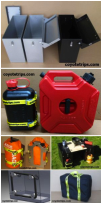

Adventure Motorcycle Luggage
& Accessories
www.coyotetrips.com
Aluminum Panniers and Top Cases,
Top Case Adapter Plates,
Tough Motorcycle Fuel Containers, & More
Designed or Curated by an experienced adventure motorcycle
world traveler
Based in Oregon
You won't find these exact products anywhere else;
these are available only from Coyotetrips
(my husband)
Disclaimer
Any activity incurs risk. The author assumes no responsibility for
the use of information contained within this document.
A friend in Kabul sent me short videos of men throwing snowballs at
each other in the beautiful, newly-fallen snow. And I love it... but
the lack of any women on the street whatsoever is heart-breaking.
#Afghanistan
Comments are welcomed, and
motivate me to keep writing -- without comments, I start to think
I'm talking to cyberair.
 Quick
Links
Quick
Links 
about Jayne
Cravens
contact me


Getting Started as a Motorcycle Rider:
My Journey (Tips for Women Who Want To Ride)
My Travel
Maps
Coyotebroad in
Germany | in
Afghanistan | in Ukraine
Coyotebroad
adventures in Europe, Africa, as well as road trips in the
USA
women
travelers: general information and advice (especially for
women novice travelers, NOT geared towards just motorcycle riders)
transire
benefaciendo: "to travel along while doing good." advice for
those wanting to make their travel more than sight-seeing and
shopping.
Permission
is granted to copy, present and/or distribute a limited
amount of material from my web site without charge
if the information is kept intact and is credited to Jayne
Cravens.
Please contact me for permission to
reprint, present or distribute these materials.
The art work and
material on this site was created and is copyrighted
1996-2025
by Jayne Cravens, all rights reserved
(unless noted otherwise, or the art comes from a link to
another web site).