Really hard to make that list - almost every day and night on
this trip was a highlight! For details about why these were
highlights, you can click on the links, which go to photos
associated with the highlights, or you can read this travelogue. I
really hope you read this travelogue.
Day One, Friday, September 2
I was so happy to hit the road for this trip at 10:30 a.m. on
Friday - that's so much better than noon or later, which we
somehow end up doing way too often. Well, I wasn't happy to
leave Lucinda the dog... I never am... but I had worked hard for
two weeks to get everything ready as much as possible so that we
weren't frantically rushing to get out of here well past lunch
time on our first day.
We had to ride on the Interstate highways through Portland,
but it wasn't anywhere near as horrible as I expected - it was
much lighter traffic for Labor Day Weekend Friday than I
expected. We even saw a motorcycle traveler on a Versys, all
loaded down, taking the exit to go south (happy riding, dude!).
Then we got off Interstate 5 north of Vancouver, Washington, at
Woodland, on Washington state road 503, and took it all the way
to Cougar for our first stop. I really like the restaurant at
the Lone Fir Resort and wanted to have lunch there. A KTM rider
came to the restaurant soon after our food arrived and it turned
out he had lived in Germany for most of his childhood - he was
excited to speak German with Stefan. I was so happy to see that
the resort had survived the Covid pandemic. We ate outside,
something I now always prefer when going to a restaurant.
No, I have never taken one of
the
resort's "Bigfoot Tours", nor have I seen Big Foot. But
this little bus was the first of MANY sightings on this trip of
attempts by towns and businesses to exploit the belief in
Sasquatch.

It was so nice to
be
back in the Gifford Pinchot National Forest. We used to
come to this national forest often when we lived on the South
Eastern side of the Portland metro area and it was so much
easier to get to. Now, we have to go through downtown Portland
traffic to get there and it's rarely felt worth it. Which is a
shame, because it's one of our favorite places to ride my
motorcycle and to camp. Being here again felt like coming home.
Plus, we are fascinated by Gifford Pinchot, the man - if you
haven't read
The Big Burn, you really need to. It's a
book I can't stop thinking about, particularly when we're riding
through forests.
We pushed on from Cougar and turned off onto Washington state
road 131, and
I
began to smell smoke. It wouldn't be the last time on this
trip.
We decided to go up the Windy Ridge road to view Mount St.
Helens on this first day out and about. After all, we had a
campsite waiting for us that we'd reserved back in July, we had
lots of time to spare and were in no rush, right?
The smoke was much thicker as we continued going up in
altitude, though it stayed high up in the sky for the most part.
The weather was getting hot and I began to wonder if the ride to
Windy Ridge would really be worth it, both because of the
temperature and the smoke-obstructed views. We had been on this
road more than a decade ago and I remember it being quite good.
Welp, once we reached it and began to ride it, I found out that,
now, it's not in good shape at all: there are jaw-jolting dips
and bumps and a lot of pot holes, especially on the way down,
and many of those holes would be trip-enders for anyone who hit
them. Many of the gaps in the road are hard to see because of
overgrown brush. If you go, pay attention, on the way up, to
where the worst spots are, and as much as possible, on the way
down, stay to the left. I hit my motorcycle skid plate HARD on a
bump going up, a bump that wasn't at all visible in what looked
like smooth asphalt. I hit so hard I thought I'd just busted my
bike.
We stopped in Randle for gas, and Stefan's bike dropped at
the gas station just as he finished fueling up. I was horrified.
He handled it very calmly - I was surprised, because every drop
does at least a bit of damage to a bike, and his panniers, up to
that point, had been absolutely pristine. I thought he'd be way
more upset. Now that the bike has dropped, his panniers are
slightly bent (though it's very hard to see those imperfections)
and, therefore, no longer water proof (such is the fate of any
metal pannier once you drop the bike - the fate of a plastic
pannier is worse). The parking in front of the gas pump wasn't
as flat as he'd thought when he parked. For the rest of the
trip, we were extra cautious every time we parked,
especially when getting gas. I was so afraid this was some sort
of horrible harbinger for the rest of the trip.
Across from the gas station in Randle was a huge encampment
of RVs. These housed individuals and families there to gather
mushrooms and huckleberries and maybe other fruit, and there
were big tents set up where the people could sell what they
gathered. I think there was a tent handing out meals as well.
What a hard life. Most of the pickers were Latino, but I also
noticed a family that looked Asian. The next time you eat
something with mushrooms gathered from Washington state or
Oregon, or drink a huckleberry something, think about the very
low-paid folks who worked their asses off in the Pacific
Northwest to pick that for ya - it's not an easy life.
There were motorcycles everywhere that day. I've never seen
so many motorcycles out on roads before, except
when
we were coming down the Alaska Highway in British Columbia
in 2015 and saw so many bikes going up. All of them this time
were headed in different directions. About half were dual
sports, loaded down with gear. About half with Harley Davidson
motorcycles, not-so-loaded down with gear. And we continued to
see a LOT of motorcyclists out traveling for this entire trip -
especially KLRs!
It was getting late and we were past the time I wanted for us
to head to our campsite at Blue Lake Creek Campground, which I
had reserved back in July, knowing that trying to get an
on-demand campsite on the Friday of Labor Day weekend would be
impossible. It was so nice to know, all day, that we had a
reserved campsite waiting for us at the end of it. Imagine our
shock to find that
Forest
Road 23 was closed for culvert repair. We were furious!
They have our email address and this apparently was a planned
road closure - it would have been easy to tell us beforehand. In
fact, I received a reminder email from recreation.gov just three
days before departure, and that email reiterated that, from
Randle, to get to the campground, we were supposed to take
Forest Road 23. With light fading, Stefan looked for the detour
on his phone: we were expected to go down Forest Road 25, get to
Trout Lake, then head to the campsite - a FOUR-HOUR DRIVE?!?

We went up and down a few other roads, finding that every
rough camping spot was full. Some were filled with RVs, who had
obviously staked out their spots the day or even two days
before. We were eventually heading up Forest Road 29. We were
gently going up, the road was quite good, but the only space
that someone could camp on was filled with two RVs, some tents
and a lot of motorcycles. Everything else was too steep or
overgrown. The road barely had a shoulder. Stefan left me at an
intersection and continued up the road looking for something,
anything, where we could pitch a tent safely for the night.
All he could find was a
large,
flat space right next to the road, with a dramatic drop
off on one side after the flat part and, on the other side of
the road, a steep cliff. We just had no choice - it was our only
option. I was really worried about a truck coming along and
plowing through out tent, with us in it. Happily, that did not
happen. In fact, there was no traffic whatsoever until about 8
the next morning, when we were up and packing. It turned out to
be a really nice, quiet, beautiful place.
I was also once again
really grateful for Stefan's
metal panniers on our motorcycles, which once again became our
seats and table, as they have on so many trips before. My bike
has dropped a couple of times with mine on them, and my panniers
are the prototypes, and, still, they have held up and are our
seats when we don't have a picnic table to use while camping.
You might think it's no big deal not to have a picnic table, but
it's really hard to unpack the bike and change out of your bike
clothes when you don't have anything to sit on or lean on except
the ground - you end up getting everything filthy very quickly.
The panniers are available
from his web site, BTW.
In the sliver of sky we could see above the road, we saw a
night sky we love so much, one where the stars are clear and
numerous - which was surprising to see, given how much smoke had
been in the air, and was probably still there. Except for the
worry of traffic and the frustration at not being told the road
was closed and losing the money we paid for the reservations, it
was, in fact, a lovely night. I'm so glad we're prepared for
such.
Day Two, Saturday, September 3
I woke up before Stefan, I think just after the sun had risen
(though I couldn't see it). I sat in the tent, listening to
something in the brush and trees above the cliff across the
road. It/they made a LOT of noise, a combination of things
dropping and some sort of animal sound, and then silence. And
then the sound would begin again. Birds? Herd of deer? Bear?
Herd of bear? No idea. I listened for a while, looked intently
into the morning twilight to see if I could see anything (I
never did), then went back to sleep. When I woke up, about an
hour later, Stefan was standing outside the tent, listening
intently to the same noise, which had never stopped. It did stop
the more we talked.
A pickup truck came up the road as we were packing up. It was
gone for about 30 minutes, then came back down. I know now, as I
write this travelogue, that the road is a dead end, as are all
the roads that branch off of it, so I have no idea where he
went. He didn't stop - just barely waved and rolled on.
We didn't make coffee - we just packed up and headed back
down Forest Road 29, and before we reached the end, passed five
boys on dirt bikes heading up the road - SO glad we left before
they came buzzing by our campsite!
We returned to Randle, intending to head to Packwood for
breakfast, but I saw a restaurant open on the corner and pulled
into the parking lot. We snagged the last available booth at the
time. I ordered biscuits and gravy, and that became something I
did repeatedly on the trip. I am stunned at how popular this
Southern dish is in the Pacific Northwest.
The
food was either really good or we were REALLY hungry. We
also met two guys there on dual sports, one an old KLR, one a
brand new one. We also saw bikers going through the intersection
during our entire breakfast, and more KLRs passing by!
We headed west to Packwood and learned why there seemed to be
even more campers than even for a holiday weekend: Packwood was
having a
massive flea market, something they do every
Memorial Day weekend as well. It looked like there were a
hundred of vendors lining the main street and even some of the
side streets. We never would have gotten near any of the
restaurants - parking isn't allowed downtown during the market.
People
parked far away, paying $10 to do so, and walked along the
road to get downtown. It was very nice to eventually get passed
the town and
back
onto beautiful backroads.
We were headed to Ardenvoir, to stay with friends. We had
decided just that morning to take them up on their offer for us
to stay there - it was the Saturday of Labor Day, and we really
didn't want to camp rough again, given how difficult it had been
to find a place. After this night, sure, I would be willing to
chance it and camp rough again, because we would be much more
likely to find a great place, but not on a holiday weekend.
Needing a break from riding after a while, I headed off
highway 12 to stop at a historical marker on Rimrock Lake. The
marker was for John and Adella Russell, who came to this area
and farmed and ranched 160 acres in the river basin. The marker
doesn't talk about the settlements there before white people got
there. Sadly, the stopping point is filled with trash. Happily,
someone put a pair of pink readers on the historical marker
sign, and they were stronger than the non-prescription reading
glasses I had brought, and
they
looked fabulous on me, so I took them. We'd passed a sign
saying there was "fire activity" on the pass, but we never saw
it.

We turned off to US
Highway 97 north and tried to stop at Liberty, which was
supposed to be our first historic town stop, but it didn't look
like it was really supposed to be a stop, despite the brown sign
announcing it as such. It's an occupied town with very few
historic buildings, and what there are are still occupied. There
is a campground there, but it didn't look like anything historic
was in it. After traveling about a quarter of a mile down the
road, we turned around and went back to the highway and pushed
on to take National Forest Road 7320 / Old Blewett road in
Wenatchee National Forest.
We
took it back in 2017 on our way to Levenworth and had
really enjoyed it. It's just 11 miles long and it's very narrow.
It's paved the whole way, but there are a lot of potholes. It
felt so much shorter than what we remembered. I was very glad
not to meet any cars or trucks on the sharper turns.
We were eventually on Alt US Highway 97, which we've been on
before, years ago. This time, we stopped in
the
parking lot of Rocky Reach Dam, which dams up the Columbia
River, for another rest. It was SO hot and I didn't want to get
dehydrated nor overheated.
My
hair... ugh. I didn't get it colored before our trip, and
I had cut it myself - damn you, COVID-19 pandemic. There was
zero moisture in the air this day and, indeed, for most of the
trip, so all of my natural curl was gone: it looked like an Emo
Phillips haircut. Plus, as you can see from photos, I've gained
almost all of the weight back that I worked so hard to lose
before the pandemic, and being at this heavier weight makes
riding a motorcycle more difficult for a whole range of reasons,
and makes the heat even more miserable for me.
We turned off for Ardenvoir, riding along the Entiat River,
and stopped at
a
store that straddles both Downtown and Uptown Ardenvoir,
to buy beer and wine - didn't want to show up at our friends'
house empty handed. It was the first time, but not the last
time, I realized just how right wing rural Washington state is -
just like Oregon, just like everywhere in the USA that's rural,
sadly. The flags, the t-shirts - so much anger, so much racism,
so much denial of reality. I know that
the
stickers on my panniers scream "LEFT WINGER FEMINIST WHO
HAS A PASSPORT",
among
other things. I don't think they will get us killed, but I
do worry about someone vandalizing the bikes as a result. So
far, it's resulted in people not talking to us - they start
walking up, they see the stickers, they walk away. That's fine
with me.
Such a lovely, special home.
Day Three, Sunday, September 4
Our hosts once again fed us and, as they prepared breakfast,
played music by the Chieftains, one of our very favorites. We
have hosted so many traveling motorcyclists at our house - it
was weird and really nice to be hosted ourselves.
We said goodbye to
our
friends after thanking them profusely and rode on,
intending to go farther North, including visiting Coulee Damn.
We stopped in the city of Lake Chelan for gas and met yet
another KLR rider. They were everywhere! Apparently Labor Day
weekend is take-your-KLR-out-on-a-roadtrip weekend. They asked
if we were doing the BDR - something we were asked repeatedly on
this trip by pretty much every dual sport rider we met. In case
you are wondering: I have no intention of doing a Backcountry
Discovery Route. They seem, to me, to be routes that are meant
just to be difficult, just to test your technical skills. I
appreciate that people are looking for that. I'm not. I love to
try a dirt or gravel road that's within my abilities, that even
takes me a bit to the edge of my abilities (but not the edge of
a cliff), so long as there is a ghost town or gorgeous vista or
great campground to experience along the way, and that isn't
going to take me more than three hours in a day to complete.
That limits me - and so be it.
The sign on Washington state road 17 said the Fort Okanogan
Interpretive Center was open, so I took it, having no idea what
it was but, hey, something historic to see! But it
wasn't
open. That is a big pet peeve of mine, when something says
open
and it is, in fact, closed. I hate when I've slowed down or
parked and found out some place I wanted to eat at or see is
closed, despite all the "open" signs. Apparently Fort Okanogan
is a site that talks about the tribes that make up the
Confederated Tribes of the Colville Reservation. It was our only
opportunity on the entire trip to visit a tribally-managed site.
We are always looking for that on a trip but rarely find it - or
if we find it, it's closed. We
stopped
on the entrance road so I could complain to the air and so
we could both drink some water. I saw an
array
of satellite dishes in the distance - but they don't seem
to be on Google satellite view of the area. Hmmmm.

The land
was
oh-so-dry
and arid, unless there was a river and farmers using such
for irrigation along the river banks. And we were heating up
more and more. It wasn't oppressive heat - we've ridden in far
worse heat. But riding in hot weather is exhausting.
At last, I saw a vista drive for the Grand Coulee Dam - Crown
Point Vista - and we took it. Apparently it's a part of
Steamboat Rock State Park, which everyone raves about online as
really beautiful, but this was NOT really beautiful - it was
dingy and run down and sad. I think it's far from the actual
campsite for the state park. This
Soviet-style
structure was built in the 1950s and is meant to be where
you
stand
to look out at the Grand Coulee Dam - which is, indeed,
GRAND. The site is worth going to for a really spectacular view
of the dam, but be prepared for a lot of trash. The dirt and
gravel parking lot is massive. There is a pit toilet near the
start of the lot. The view of the dam is scenic, but the
viewpoint - not so much.
The Grand Coulee Dam is an engineering marvel. It is SO big!
It is so very, very large. It's worth your time to look it up
online and read about its history. And maybe it's worth it to do
the officia tour, but we just didn't feel like it.
We were hungry and needed gas, so we decided to head
down
into the cities below the dam to look for food and fuel.
The town below is filled with very lovely vintage homes with
lush, green lawns. But no restaurants or other services. We went
across
the bridge to the other side, which didn't look nearly so
green or lush, and I stopped at the first restaurant I saw, a
Mexican restaurant. We sat eating mediocre Mexican food and
enjoying the air conditioning and watching the dam out the
window of our booth. I kept thinking about what a disaster it
would be if the damn burst. Has that happened in any disaster
movies? Send me a YouTube link to the scene if so.
I'm disappointed in myself for not getting a photo of myself
next to the GIANT FDR HEAD at the dam. But I didn't see it in
time to make the turn and didn't feel like turning around. As a
result, I have no photo of me next to the GIANT FDR HEAD.
We headed back up past the dam and onto Oregon route 174, then a
bit West on US Highway 2, to visit our first ghost town of the
trip:
Govan.
I found this and other ghost towns by typing in phrases like this
to Google:
- historic town Oregon
- ghost town Oregon
- abandoned town Oregon
- historic town Washington state
- etc.
There are some web sites that you will find if you do such
searches that list what the authors of those sites consider
ghost towns, as well as articles written by various folks about
ghost towns. I read them all and try to sift through the fluff
and figure out what's really worth seeing/visiting. It's not
always easy to use such research: some of the articles
plagiarize other articles, changing this or that to make the
town sound most interesting, and often, the author has never
been to the town at all, they just created the site as
clickbait. I have
a
list of ghost towns we've visited, btw, with accurate
descriptions - no fluff!

The area of Govan, Washington, contrary
to what I'd read online, isn't really a ghost town - there are
still some people living there, and the grain elevator looks
like it's still an active business.
The
community that was Govan is, indeed, long gone, including
most of the buildings. Still, it was worth visiting to
see
inside and around the historic schoolhouse, which must
have been beautiful when it first opened, and an abandoned house
with
a
stove that I so, so need, so I can build my dream house
around it. We even saw some deer around the abandoned house -
they were too far away for a good photo.
The
schoolhouse still has shingles with the vibrant red paint on
them, that must have been all over before fading in the
sun. It made me sad - to see what was obviously such a beautiful
building abandoned and soon to fall completely apart. This
wasn't a quickly-built structure: it was built to be both
practical and beautiful. What a shame it couldn't be
re-purposed.
We headed back on US Highway 2 and then north on Washington
state route 21, going through Wilbur but not stopping for
hamburgers there this time, to cross the Columbia River on the
Keller Ferry (free!). The ride down to the ferry, BTW, is
suddenly twisty, with a steep decline, and really beautiful. We
were hoping there would be a campground on the other side of the
river, not too far from where we would dock. It was Sunday
evening, and there is a state park right at the ferry dock
before we boarded, but I just didn't feel like a state park:
they are expensive and full of RVs running their generators. And
I wasn't needing a shower yet, as I'd just had one. Stefan's map
showed a campground a few miles after we reached the other side
of the river, so we were hopeful.
There was another biker on the ferry, with a very expensive,
new BMW. He had no interest in talking to us. Such people always
make me feel stupid when I try to talk to them - their
expression and body language make it clear I am REALLY bothering
them. I certainly don't want to bother anyone. I just like to
ask people where they are from and where they are going. Or
where they've been. I've gotten some great road and site
recommendations as a result. It seems like the newer and more
expensive the bike, the more I get this reaction. Oh well.
We went off the ferry, traveled up the road, and came to what
was listed on our paper map as a campground.
The
sign says its a trailhead and never mentions any campsite,
13 Mile Trailhead does have four or so campsites, each with a
fire ring and picnic table. It also has a pit toilet and, just
like most of the time with other vault toilets, it was clean and
well stocked with toilet paper. Thank you, National Forest
Service! It's just off highway 21 at the boundary of the
Colville Indian Reservation. It's officially in the Colville
National Forest and the nearest town is Republic, Washington. It
was my second favorite campsite of the entire trip. It's in a
canyon and the cars from the nearby highway die down as soon as
the ferry stops running for the day. It has a bear-proof
trashcan, and we made sure all of our food, food prep tools,
toiletries and anything else smelly were in our panniers.
My bike was sounding and feeling funky. We had taken a ride
the weekend before our trip and I felt this kind of "thunk
thunk" every few seconds, as though I was about to start running
out of gas. We were both afraid it would kill our trip -
something we were both needing, badly. Stefan did a number of
things to the bike in the following days and I crowd sourced the
problem on a KLR forum on Reddit, to give him even more ideas to
try. Nothing fixed the issue. He rode the bike repeatedly and
said it was running fine and we could still do the trip. So... I
went with that and hoped my motorcycle would hold up. But that
"thunk thunk" feeling continued for the entire trip, and later
turned into a sound. The only time I didn't notice it was when
we were on a gravel road. The bike did make it through the
entire trip and got me home just fine, but I was really holding
my breath that last day. But more on that much later...
Stefan felt that our chains were too loose, so he did some
maintenance on them. And then we had a perfect night at the
campsite, drinking way too much beer and wine. Well, maybe that
was just me. I think I heated up a can of something. I don't
remember. I just felt so relaxed and happy. It was a magical
night. The stars were gorgeous. I went to sleep very tipsy and
feeling like all was right with the world.
Day Four, Monday, September 5
Happy Labor Day! Workers of the world, unite!
I had so loved Thirteen Mile Trailhead as a campground - I
wish sites like this were prolific! It put me in a very happy
mood for the day. We made coffee and I used my
Eagle
Brand Sweetened Condensed Milk in a pouch in my coffee for
the first time. OMG... it is now mandatory for my camping trips.
I have tried powdered creamer, and it's just nothing. Instant
coffee is something I drink only when I'm motorcycle camping,
and it needs a lot of help for me to drink it. And I
need
to drink coffee in the morning. Someone in the comments section
of
Outdoors or
Backpacker magazine on Facebook
suggested sweetened condensed milk as a great substitution for
flavored creamer and THAT PERSON HAS CHANGED MY LIFE. When I
went to the grocery looking for it, I thought I would be getting
a can or two - never dreamed there would be a pouch! Perfect for
travel!
For breakfast, I had peanut butter out of an individual
serving container - we didn't have enough water for me to have
oatmeal and to clean the dishes.
We headed on to the town of Republic to get gas, and while
there, Stefan rechecked his motorcycle chain tension - and found
that his chain had NOT been as loose as he thought in the
campground and it was now MUCH too tight. I was stunned at how
quickly he took off his bike seat, redid the chain tension and
then put it all back together. Then we headed on through
Republic, which actually was kind of quaint.
Below is a screen capture of our route that day, so you can
see where we went and how we went , because it's hard to explain
in narrative form. The little tent marked 03 is Thirteen Mile
Trailhead as a campground. Yes, as you see from this map, we
went through Wauconda. I kept yelling "Wakanda Forever" in my
helmet. Spoiler alert: Wauconda is NOTHING like Wakanda.

My pre-trip research for abandoned historic towns - ghost
towns - to visit on this trip turned up Bodie, Washington.
Imagine my surprise to find out it was named after the same
person as the iconic Bodie, California, the best-preserved ghost
town in the USA and my favorite abandoned historic towns: the
original claim holder was William S. Bodey "whose eponym was
changed as his tent city was underway, as an anonymous sign
painter assumed the spelling of Bodie would wear better with
time." We almost didn't find Bodie, Washington - Stefan had
marked it on his GPS but it wasn't at that point when we came to
it, and we thought maybe it wasn't there at all. It turned out
to be about half a mile further down the road,
with
a sign and a fair number of buildings.
We continued North, heading to
historic
Molson in Okanogan County and seeing along the way lots of
old houses and buildings just like what we had seen in Bodie,
some abandoned, but some still in use as storage or even living
spaces. One or two had a sign marking that it was a historic
site, but with no further information, outside of it, but we
didn't stop at all of them since, at many, there just wasn't
much to see. After dodging a few cows on the road, we were
nearing Molson, and we saw a really huge old building - it
looked like it might have been a hotel - out in the middle of a
field. I didn't see a "no trespassing" sign and the gate was
wide opened, so in we went.
We
started taking photos and walking around - and then heard
the voice of someone from across the street, telling us it was
private property. And he was PISSED. Knowing that many rural
people in the USA are armed and will just start shooting, we all
but ran to our motorcycles and left - and unfortunately, the
fabulous pink readers that I had found earlier, that I had
hanging on my collar, must have fallen off somewhere in his
field. I missed them greatly for the rest of the trip... I had
brought Costco cheap reading glasses with me (no way I'm
bringing my expensive prescription glasses), and they were fine
for when I needed to read a menu or whatever but the pink
readers were FABULOUS.

Onward to
historic Molson, an open-air museum of many historic
buildings
and artifacts -
tractors,
tools,
typewriters,
a
printing
machine,
household
items, and so much more. I believe the buildings and items
were all moved here, to this one spot, from various places
around the area.
I
was enchanted by it all. It's like a mini-Bodie,
California. I'm so, so glad it was open, officially, on Labor
Day! It's so, so far North and far from everything, I'm not
surprised at the few number of visitors, but I thought it was so
worth it.
Molson included what I think is
a
planting machine, and it had the word Kentucky on it.
Attached to it is
a
guide that says "Grain Sowing Tables, Internal feed
drills", for the planting of wheat, barley, buckwheat, kaffir,
corn, rye, flax, oats, beets, peas, navy beans, ensilage corn,
kidney beans, canning peas and more.
This ride on this day, and several others on this trips, so
well represents why I wanted a dual sport motorcycle: not to do
the BDR, not to do crazy difficult dirt and gravel roads, but to
be able to go for a few, even several miles, see some site
somewhere I really want to see or camp somewhere a bit obscure.
I love my KLR so much for that reason. I know that most street
bikes could do what I've done, but a dual sport makes it SO much
easier - and I used to ride a Honda Nighthawk, I know what I'm
talking about.
It was only 3 p.m. when we finished our visits to Old Molson
and Sidley, British Columbia, but I was DONE. So done. What a
huge full day. We had passed two lovely lakes on the way, Beth
Lake and Lake Beaver, in Colville National Forest, and one of
them had a campsite. I suggested we call it an early evening and
camp there. And so we did.
There was no where to get beer or wine for the evening, but
that was okay - we really were too tired to drink. The day
wasn't over though:
underwear
needed washed again. I walked up and down the driveway for
our loop of the campsite to get water from the only water spigot
we could find, maybe the only one in the entire campground. I
think I made that walk five times. I used our collapsable sinks
to haul the water for washing and cooking. I kept saying, "I'm
like a pioneer woman!" But the reality is that it still wasn't
as long a walk to water as what my rural great-grandmothers did
as children, probably.
I'm so glad Stefan
brings
the clothes line. It's one of those things a lot of other
adventure motorcyclists, bicyclists and hikers say you don't
really need, that it's easy to improvise, that it's just another
thing that adds weight to your bike. We disagree. If you camp,
you need it.
I continued to reach deep and gather some energy so I could
cook a good supper, since all we'd had for lunch was snack bars
and water: I heated up Tasty Bite Turmeric Ghee Rice and and
Tasty Bite Vegetable Tikka Masala, both out of a pouch. I added
a lot of extra curry and chili powder. It is amazing how good it
tasted after such a long day, and in such an isolated area, and
after not eating much all day. The Tasty Bite brand has really
improved our camping supper experiences - we use them on both
motorcycle trips and when car/trailer camping.
So, there's why Tasty Bite brand and/or Eagle Brand need to
sponsor our motorcycle trips. Just cover our fuel costs!!
And I continued to fight off my extreme tiredness and after
initially saying not, I decided we should, in fact, walk to one
of the lakes and have a closer look, and then walk through the
entire empty campground, just to see how it was laid out.
There was just one other campsite occupied on this Labor Day
- and we were as far apart as we could be (we'd chosen a site
near the water spigot). The pit toilet was also nearby. It was
like glamping! Well, at least for us.
I was dead to the world by nightfall. Geesh but I was tired.
I was asleep before 8:30 that night. But I did see beautiful
stars the times I got up to pee.
Day Five, Tuesday, September 6
It was time to retire the t-shirt I had been wearing the
entire trip so far,
the
one with Harrison Ford as Han Solo on the back and change
to something clean. I don't try to hand wash t-shirts on trips
because it's impossible to get them clean that way, at least
when I try it, and they don't dry overnight. I take enough
t-shirts to change every three to five days, as needed.
On this trip, I brought a both practical and sentimental
tool. My maternal grandmother died in late 2019, a few months
after I had visited her for the last time. A lot of her stuff
ended up at my mother's, and I went back to Kentucky in June to
clean some things out of her house and found a few of these
little pocket knives from my grandmother's former workplace,
Gamco Products.
I
now take one on the motorcycle with me. You can see
my
entire motorcycle pack list here, BTW.
We had coffee and our breakfast (I don't remember what we
had) at the campsite, then moved on, now heading mostly East. We
drove through Curlew, which is described somewhere as an
historic town, a kind of ghost town, but it's not at all -
people live there and there aren't that many historic buildings
to admire. Cool bridge though.
One of our stops during the day was at
Sherman
Pass Scenic Byway, because it had a pit toilet and I
needed such at that moment. At the stop, I found several
Infowars stickers stuck on the back of a parking sign. I
carefully peeled each off and threw the sh*t away in the pit
toilet - that's what you do with crap, right, it goes in the pit
toilet? I did the same throughout the trip. I love doing public
service activities while traveling!
While riding on state highway 20 in Washington State, through
Colville National Forest, I saw a sign on the side of the road
for
historic
Camp Growden, a Civilian Conservation Corps (CCCs). Being
a total CCC fan girl, of course I stopped! I was in heaven - I
LOVE all things CCC!
Camp
Growden was one of the largest CCC camps in the area and
known as “Little America” because it housed enrollees from
around the USA. CCC workers built roads, trails, camps, and
buildings all over the USA, many of which are still in use today
- your city or county probably has something built by the CCC
back in the 1930s. I love the CCC!! Thank you, FDR!

I was
now wearing my newest t-shirt, one that
has
a Coyotebroad design on it. I had worn it just once
before, to
the
big outdoor overland expo in Redmond, Oregon earlier this
year. I want to make some changes to the design for the next
version of the shirt - it's so difficult to design online! There
will be just one more, maybe two more t-shirts. I'm not going to
sell them or anything, therefore I don't need more than a
couple. I'd just like to be wearing my own "brand" in more
travel photos. You may have noticed that I'm using
coyotebroad.com more than coyotecommunications.com - I'm doing
that because, as I work less and less, I want to start promoting
my travelogues and travel advice more and more online. I doubt
it will ever become a viable business; the market is just so
saturated with travel bloggers and travel advice and influencers
and what not. I don't really offer anything unique, except for
my really detailed travelogues, which most folks don't do. I'll
never have a following like
ItchyBoots,
mostly because I'm not willing to put in the time, and the
quality of work, that she pours into telling about her travels
(which is the industry standard, hands down) - plus, I'm just
not that adorable!
At some point on our ride, I saw that Stefan wasn't behind
me. I panicked. I pulled over to the side of the road where I
thought it was safe, and waited. Did he have a flat tire? Had a
deer run out in front of him? Was he okay? With every second, I
got more and more nervous. Finally, I decided to count to 60
and, if he didn't show up, I would turn around and go see what
had happened. But not long after I started counting, he showed
up. Turns out he'd pulled over to take a photo of his Honda
Africa Twin speedometer, which had turned to 160,000 kilometers
- 100,000 miles.
There were so many, many Bible camps everywhere. We saw so
many Bible camp compounds, or signs for such, on this day and on
this entire trip. It was creepy. The ones we saw looked very
well-kept - and, therefore, well funded, .I have a feeling what
people are learning is far, far off the mainstream. These are
the same as madrasas, yet the people that get upset about
madrasas just ignore these - and send their kids to them.
As happened frequently on this trip, we didn't have even an
abstract plan that morning on where to stay that evening, and
then had to scramble to find a place to camp suddenly before
night fell. We ended up at
Skookum
Creek Campground, still in Washington state, very near
Idaho border. This was our first experience with a campground
managed by the Washington state Department of Natural Resources
(it's NOT the same as a state park). DNR manages 80 campgrounds
across the state and the only way to pay to be at one is to have
a one-day or one-year Washington State Discover Pass - and you
can only do that via your phone at the campsite (there's no way
to pay otherwise). Good thing Stefan's phone worked! Also, none
of the QR codes to pay work, because someone put
the
bolt to hold the sign up through the edge of the code.
Really happy to see
the
sign recruiting volunteers to help at DNR-managed sites
(which aren't just campgrounds).
The campground was fine, except for a lack of toilet paper in
the pit toilet (UNACCEPTABLE). We were also on edge all evening
because of the at least two sites that were occupied by people
living in their cars (this is a growing issue at campgrounds, no
matter how remote). We were really worried about bugs, given the
nearby standing water
in
the meadow, but it was fine. There were
signs
everywhere saying "no campfires!" and we always adhere to
that rule if it's in place.
Great view of the stars at night! Wish I hadn't been so tired
and could have stayed up and watched them for a while.
The travelogue continues in part 2.
And now a word from my husband:
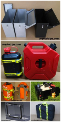
Adventure Motorcycle
Luggage & Accessories
www.coyotetrips.com
Aluminum Panniers and Top Cases,
Top Case Adapter Plates,
Tough Motorcycle Fuel Containers, & More
Designed or Curated by an experienced adventure
motorcycle world traveler
Based in Oregon
You won't find these exact products anywhere else;
these are available only from Coyotetrips
(my husband)
Return to the Coyotebroad travel
home page.
Follow me on social media:


Disclaimer
Any activity incurs risk. The author assumes no
responsibility for the use of information contained within
this document.
_______________________________________________
If you have read
anything on
coyotebroad.com, PLEASE
let me know.
Comments are welcomed, and motivate me to keep writing
-- without comments, I start to think I'm talking to
cyberair. I would welcome your
support for my work as
well.
 Quick Links
Index of resources for women
travelers (how
to get started, health
& safety considerations, packing suggestions, transportation options,
etc.
Advice for women
motorcycle riders and travelers.
transire benefaciendo:
"to travel along while doing good." advice for those
wanting to make their travel more than sight-seeing and
shopping.
my adventures in Europe,
Africa, as well as road trips in the USA.
Advice for camping with
your dogs in the USA.
Saving Money with Park Passes
in the USA.
Suggestions for
Women Aid Workers in Afghanistan (or anywhere in
the world where the culture is more
conservative/restrictive regarding women).
my adventures
in Germany.
Advice for Hotels,
Hostels & Campgrounds in Transitional &
Developing Countries: the Qualities of Great, Cheap
Accommodations.
 how to support my work.
Follow me on social media:
Disclaimer: Any activity incurs
risk. The author assumes no responsibility for the
use of information contained within this document.
This material is provided as is, with no
expressed or implied warranty.
Permission is granted to copy, present and/or
distribute a limited amount of material
from my web site without charge if the
information is kept intact and is credited to Jayne Cravens.
Please contact me
for permission to reprint, present or distribute
these materials (for instance, in a class or book
or online event for which you intend to charge).
The art work and material on this site was
created and is copyrighted 1996-2022
by Jayne Cravens, all rights reserved
(unless noted otherwise, or the art comes from a
link to another web site).
The personal opinions expressed on this page are
solely those of Ms. Cravens, unless otherwise
noted.
