Two Weeks in Idaho (mostly):
a Motorcycle Adventure
September 2016
Two Weeks in Idaho (mostly):
a Motorcycle Adventure
September 2016
Friday (Day One)
I was determined to not delay us, so that we could be off by 10 a.m., something I've never managed to do before for a motorcycle trip. I did as much as I could in the days leading up to departure, trying to pretend we were leaving Thursday instead of Friday so I'd get everything done. Friday morning, I threw away food from the fridge we couldn't take - and it was more than usual, and that made me sad - and I walked Lucinda the dog early and for a long time. Then I made the mistake of letting her in the backyard after the walk, and she did her usual I'm not coming in! game. On the verge of tears, there was a knock at the door - it was my friend Samantha and her dog Harry - my dog sitter would be taking care of Harry as well for the first three days. Lucy was only too happy to come in and be with yet another of her boyfriends.
We almost made it out just after 10. But then, we mounted our motorcycles, pressed start - and Stefan's Honda Africa Twin battery was dead. So many wires and a trip to Ace Hardware and two hours later, we were, at last, on our way.
We had to do most of the first day via I 84, through the Columbia River Gorge, but not at break-neck speed. It was Friday afternoon, and traffic up to and through Portland and Gresham... it was awful. Our earlier delay landed us in the worst of it. But Zephyr was kind that day and decided to not try to blow us off the road in the Gorge. We had lunch at Charburger in Cascade Locks, where we'd eaten back in 2014 on our trip to Utah. And I once again felt great lust in my heart for a night or two at the historic Columbia Gorge Hotel & Spa.
We continued on I 84 East, stopping at a rest stop on the way. It was SO HOT. Sweat was pouring off of us. Stefan had insisted we wear our mesh jackets, which create air flow through the jackets all over our arms and torsos, and he was right - there was no way we could have survived this and other days in regular motorcycle jackets. I was doing my best to stay hydrated, but that meant I also had to pee a lot. There was a conservative Muslim family at the rest stop, having a late meal. The women were all fully covered, one of them in a chador showing only her eyes. The men were in short sleeves. I think I would feel differently about their clothes if they were like the Amish, with men also being required to dress oh-so-conservatively, especially in this horrible heat. That said, the ban on burkinis at some French beaches is so STUPID - women should always be able to wear whatever they want. I'm much more offended by having to see fat men in swimming briefs.
Even in the heat, on the freeway, I was feeling good about riding. I don't say enough about how much I enjoy riding a motorcycle, or why. I like how present one has to be to ride a motorcycle. I like how it takes my mind off everything else. It feels like a workout for my mind, a defragging of the brain that I very much need regularly. In some ways, motorcycle riding feels like EMDR. It's clichéd to say it, but a motorcycle ride feels like an extension of myself, or who I want to be. True, I've been having some problems with it since 2014, since my wreck - I'm not as calm as I used to be, and some activities seem so much harder than they were before, requiring so much concentration I feel much more exhausted after a ride than I should. Even so, after a complicated ride, I do often feel triumphant... but never infallible. Never super human. I don't speed - I'm in it for the scenery and the skills, not the speed.
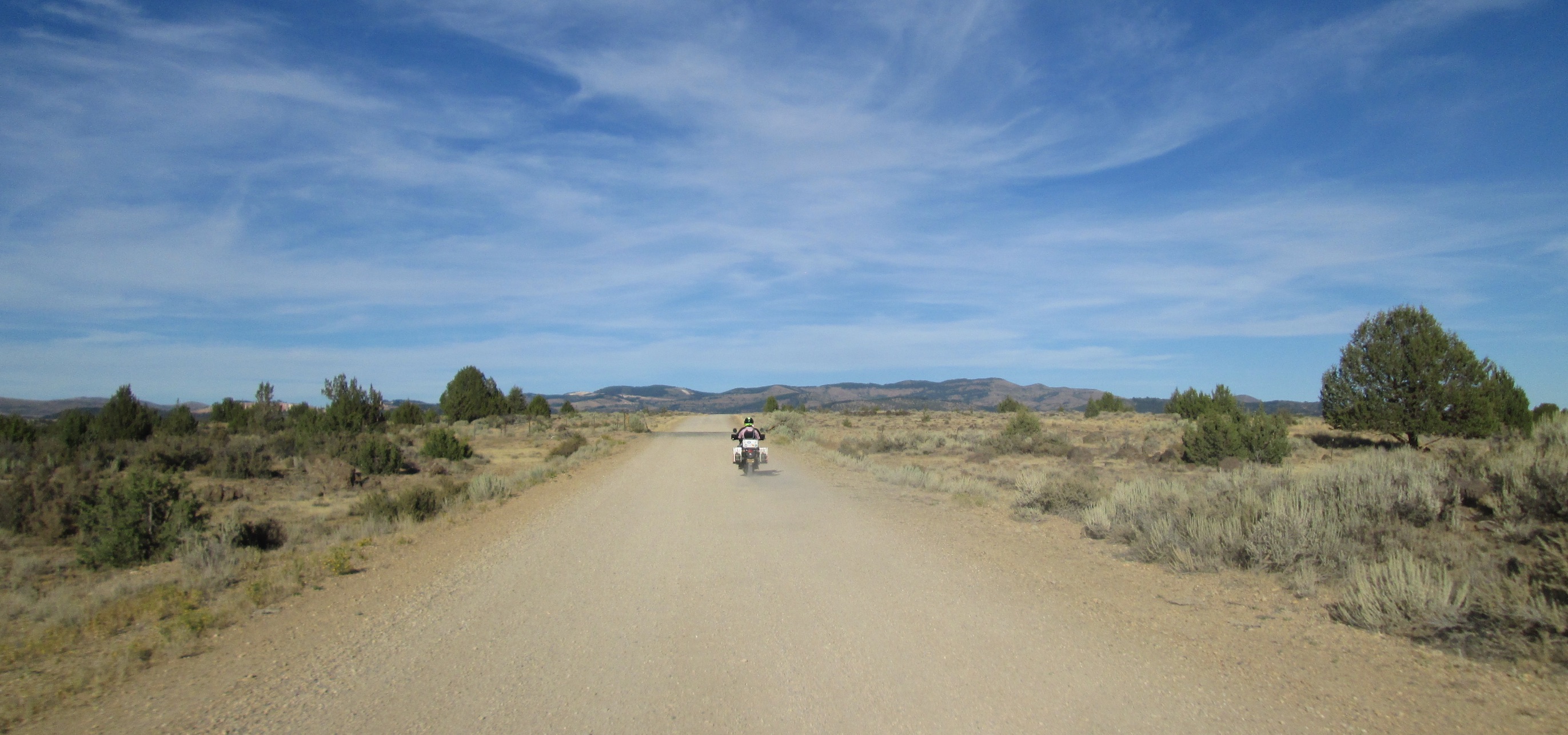
We got off the highway at La Grange and went through historic downtown, which I thought it was charming. Then we went to the oh-so-sad little town of North Powder, and found a place to buy ice and beer. Then we headed to the Anthony Lakes area, to a campsite in the Little Alps area. It was a lovely ride to the campground, with deer on the side of the road rather than on it, but it was getting dark fast. By the time we chose our campground and campsite and got our tent up, it was night. It was quite a cold night, not quite freezing - after the horrendously hot day, it felt great. We stood looking at the clear stars as it got colder and colder, watching the Milky Way emerge. I was tucked away in my sleeping bag by 9:30, and I slept 11 hours. I call that a reboot. It felt like we were already, immediately far, far from home - something I rarely feel on the first night out. It was a beautiful place, and a beautiful feeling.
Saturday (Day Two)
The next morning, we discovered we had gotten one of the last open sites in the campgroud - it had been avoided by others because it couldn't be used by most camping trailers or RVs. Lucky us! I cooked a big breakfast with all of the eggs we brought. It was early enough that we had time to walk down to the lake - I love taking a little hike before bed or before we leave in the morning.
We packed up and headed down beautiful, curvy, empty National Forest Road 73, disturbing a coyote pup trying to catch a nap in the sun on the road. We continued on back roads to Baker City, Oregon, which I'd read was historic and scenic. We had lunch there at the Geiser Grand Hotel, built in 1889 as a luxurious, high class hotel. In the basement, known as the wine cellar, one can still see large window-like doors that, supposedly, once opened up to underground passageways, so gentlemen could enter discreetly without being seen by other members of proper society, in order to enjoy carnal pleasures with the prostitutes upstairs in the third floor. The hotel has been restored and is quite luxurious, but you aren't allowed to see much of it unless you are a paying guest (the front desk staff will stop you if you try!). There was a "motorcycle club" having lunch there too. I'm not going to say the name, but they had it all: the backpatch on the leather vests and jackets, the Harleys... and, no, it was not the MC you're thinking of.
We headed West on State Road 86, and I pulled into the driveway for the National Historic Oregon Trail Interpretive Center, which sits atop a hill five miles east of Baker City, Oregon. It offers dramatic views of the actual trail pioneers once traveled on to reach Oregon. We had a nice chat with two couples on BMWs, retired and touring some Western states. We appreciated that the center's exhibit didn't describe the pioneers as perfect or God-like, that it described their many faults as well their strengths. We also appreciated the air conditioning... it was SO HOT outside. You will notice when you go to the Flickr album for our trip that photos for the trip itself start at the interpretive center; that's because Stefan forgot to put his camera memory card back into the phone before we left, and he had to buy one in Baker City. Our cell phones are cheap - they can do photos, but not very good ones.
 The
ride became immediately more beautiful, and it
felt like there were no towns anywhere around us. We seemed
to always be going in and out of canyons - not just this day, but
on most other days of the trip as well. This part of Oregon was
new to us - somehow, we've lived in Oregon for seven years, riding
motorcycles, and never ridden to Hells Canyon, which is a mecca
for motorcyclists. I was excited and nervous. How steep would the
hills be? How sharp would the turns be? How severe would the
drop-offs be? And would it stay this hot?
The
ride became immediately more beautiful, and it
felt like there were no towns anywhere around us. We seemed
to always be going in and out of canyons - not just this day, but
on most other days of the trip as well. This part of Oregon was
new to us - somehow, we've lived in Oregon for seven years, riding
motorcycles, and never ridden to Hells Canyon, which is a mecca
for motorcyclists. I was excited and nervous. How steep would the
hills be? How sharp would the turns be? How severe would the
drop-offs be? And would it stay this hot?
We found a Hells Canyon information board out in the middle of now where. I was covered in sweat. I didn't care. I was in a good mood - I was on vacation! I was hating my hair though - straight and lifeless. I'm vain and like to look good in photos - and my hair was making that impossible. Still, I'll almost always strike a pose.
We arrived at Copperfield Park well before dark. It's a campsite in a tiny town, Oxbow, with no gas station, no store of any kind, and is right on the Snake River, downstream of Oxbow Dam on the Oregon side of the river - we could see the river from our campsite. The campground is managed by Idaho Power, and therefore follows the Idaho time zone instead of Oregon. It was just $10 for tent camping, with access to flush toilets and showers, all very clean and plentiful - it's a bargain! But I was tired and did not want to be in the photo. I was also ticked off: we'd both forgotten our checkbooks, which meant we would have to pay cash at all camp sites. I ask the camp host if he could change a 20, and he snapped "Nope. There's a gas station two miles down the road" and turned and walked away. He was so pleased to tell me no. What a jerk. Guess that whole "host" thing is lost on him - he just wanted the free camp site.
The RV campers near us housed three couples there to celebrate one of the couple's anniversaries. The woman surprised the man by walking out of the RV wearing the wedding dress she wore many years ago. It was very sweet.
That night, we laid on the picnic table benches for a while, drinking beer and looking up at the stars. We saw some falling stars and, as we saw every night of this trip when camping, the Milky Way. How sad that there are people that have never been able to see it.
Sunday (Day Three)
 Breakfast
this time was yogurt, a boiled egg and coffee. We were packed up
and out by 10:30 a.m. Idaho time. It was time to take the Hells
Canyon drive from Oxbow Bridge along the Snake River to the Hells
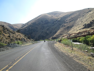
Canyon dam. It's not a loop - you go to the dam, turn around, and
ride back. And it's so worth it. It's a very beautiful, intense
ride, with curves and dramatic rises and falls in the road - a bit
of idea of it is to the left. The views are quite dramatic. This
is North America's deepest river gorge, at 7,993 feet (2,436 m) -
yes, deeper than the Grand Canyon. The Snake River began carving
Hells Canyon out of the plateau about 6 million years ago. The
earliest known settlers in Hells Canyon were the Nez Percé tribe.
In 1806, three members of the Lewis and Clark Expedition entered
the Hells Canyon region, but they turned back without seeing the
deep parts of the canyon. It's not Hell's Canyon, but Hells
Canyon, named for someone with the last name of Hells.
But hellish things have, indeed, happened in the area: in May
1887, perhaps 34 Chinese gold miners were ambushed, robbed,
murdered, and mutilated by a gang of white men. It is recalled as
Hells Canyon Massacre and is commemorated
with a plaque now. Had I known about it when we were on the
trip, I would have insisted we visit the plaque, but I found out
about it only after getting back home.
Breakfast
this time was yogurt, a boiled egg and coffee. We were packed up
and out by 10:30 a.m. Idaho time. It was time to take the Hells
Canyon drive from Oxbow Bridge along the Snake River to the Hells
Canyon dam. It's not a loop - you go to the dam, turn around, and
ride back. And it's so worth it. It's a very beautiful, intense
ride, with curves and dramatic rises and falls in the road - a bit
of idea of it is to the left. The views are quite dramatic. This
is North America's deepest river gorge, at 7,993 feet (2,436 m) -
yes, deeper than the Grand Canyon. The Snake River began carving
Hells Canyon out of the plateau about 6 million years ago. The
earliest known settlers in Hells Canyon were the Nez Percé tribe.
In 1806, three members of the Lewis and Clark Expedition entered
the Hells Canyon region, but they turned back without seeing the
deep parts of the canyon. It's not Hell's Canyon, but Hells
Canyon, named for someone with the last name of Hells.
But hellish things have, indeed, happened in the area: in May
1887, perhaps 34 Chinese gold miners were ambushed, robbed,
murdered, and mutilated by a gang of white men. It is recalled as
Hells Canyon Massacre and is commemorated
with a plaque now. Had I known about it when we were on the
trip, I would have insisted we visit the plaque, but I found out
about it only after getting back home.
I did well on the Hell's Canyon road to Hells Canyon dam, though I did hit a foot pedal or my center stand on the ground once while taking a curve. After crossing the Hells Canyon dam, you do three turns, one of them the perfect definition of hairpin, and then drive up to the information center. There's not much in the information center, but it's nice to talk to the park rangers there - I love national park, monument and forest employees, BLM employees... I'm a groupie. I am so thankful for their service. While at the site, we got to watch people who camped across from us launch a large raft into the river below.
Stefan then mentioned something I hadn't realized on the way down: on the way out was going to require doing that hairpin turn to the right and entirely uphill on a steep incline. Right hand uphill hairpin turns are the absolute hardest for a motorcycle. I can do that right hand hairpin turn flat or downhill, but uphill - it makes me want to cry thinking about it. It's exactly the kind of turn I crashed on at Shafer Switchbacks in 2014, sans gravel and dirt. And there was no way for Stefan to ride my bike for me around it without a huge delay - he would have to ride about half a mile, then park my bike and walk back to me. I couldn't ask him to do that. So, up I went. I made the turn, but went FAR into the opposing lane - thank goodness no car was coming.
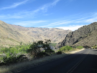
Back through the canyon where we'd just come (stopping for a photo), back by Copperfield Park and back onto state road 71, which continues along Snake River and eventually takes you up and over Oxbow Dam, a rockfill dam. It's a very dramatic run up to the dam, and then very curvy roads with scary drop-offs off the road, and somewhat steep inclines out of the canyon. I lucked out - there were no bikers behind me. Probably because we stopped at the bottom of the dam and I let all the bikers go up before me. We eventually ended up behind three vintage cars out for a cruise, going so slowly I actually passed them in double-lined parts of the road - it was more dangerous going uphill slowly behind them, IMO.
We stopped for lunch in Cambridge at a cafe that really needs an "open" sign so it can be seen by people coming from Hell's Canyon or from North on 95. Cambridge is a major stopping point for motorcycles. I could have watched them arriving and leaving at the gas station on the corner all day. We met some adviriders from Canada at the Cafe - they were going to do the Idaho Backcountry Discovery Route, something far outside my abilities.
 We
headed South on 95. At some point, we
passed hops growing. From Cambridge, Idaho to Jordan Valley,
Oregon it's 130 miles of yuck. It's awful: nothing scenic, lots of
traffic, and very few places to stop for food or something cold.
The only thing scenic we passed the entire time was a public
library in Parma, Idaho, housed in what looked like an old bank
building. And it was hotter than Hades. We were miserable.
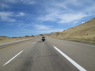
There was just one part of the road that was scenic - see at left.
We
headed South on 95. At some point, we
passed hops growing. From Cambridge, Idaho to Jordan Valley,
Oregon it's 130 miles of yuck. It's awful: nothing scenic, lots of
traffic, and very few places to stop for food or something cold.
The only thing scenic we passed the entire time was a public
library in Parma, Idaho, housed in what looked like an old bank
building. And it was hotter than Hades. We were miserable.
There was just one part of the road that was scenic - see at left.
We got to Jordan Valley and were stunned to find it so greatly changed from when we were last there in 2011: now, there were no bikers at all, many were now closed, and the gas station looked like it has fallen on hard times. Our crossroads for motorcycles, bustling with bikes, was now sad and lifeless. A bleached blond woman got out of a car and she looked like leather, like a poster child for too much sun and tanning booths. I gasped when I saw her and had to turn away. The entire stop was beyond depressing.
I had really wanted to stop for the evening, but there was no where to go nearby - Birch Creek Historic Ranch is almost 30 miles away, and not in the direction we wanted to go this trip. So, reluctantly, I agreed to push on to Silver City, Idaho. Time to cowgirl up...
And then the adventure really began...
Part 2: Historic Silver City, Idaho
Return to the Coyotebroad travel home
page.
Disclaimer
Any activity incurs risk. The author assumes no responsibility
for the use of information contained within this document.
Disclaimer: Any activity incurs risk. The author assumes no responsibility for the use of information contained within this document.
This material is provided as is, with no expressed or implied warranty.
Permission is granted to copy, present and/or distribute a limited amount of material from my web site without charge if the information is kept intact and is credited to Jayne Cravens.
Please contact me for permission to reprint, present or distribute these materials (for instance, in a class or book or online event for which you intend to charge).
The personal opinions expressed on this page are solely those of Ms. Cravens, unless otherwise noted.